Home

Secondary Menu

  • Careers
  • People
  • Blogs
  • Events
  • For ANR Employees

User account menu

Log in Donate
Home

Main navigation

  • About
    • Overview
      • About UC ANR
      • Take a Virtual Tour
      • Strategic Vision
    • Staff & People
      • Search People
      • UC Agricultural Experiment Station
    • Stay Engaged
      • Get Involved
      • Support Us
      • Volunteer
  • Locations & Centers
    • Counties
      • Alameda
      • Amador
      • Butte
      • Calaveras
      • View All Counties
    • Research and Extension Centers (RECs)
      • REC Overview
      • Desert REC
      • Hansen REC
      • Hopland REC
      • Intermountain REC
      • View All RECs
  • Topics
    • Topics
      • Agriculture
      • Fire
      • Forests
      • Nutrition & Health
      • Pest Management & Plant Health
      • Rangelands
      • Water
      • Youth Development
      • Yard & Garden
  • Programs & Institutes
    • Agriculture
      • UC ANR Innovate
      • UC Integrated Pest Management Program
      • Sustainable Agriculture Research and Education Program
      • UC Organic Agriculture Institute
      • UC ANR Small Farms Network
      • Research and Information Centers (RICs)
    • Environment
      • California Institute for Water Resources
      • UC Environmental Stewards
      • Informatics and Geographic Information Systems
      • UC ANR Fire Network
    • Health & Nutrition
      • Community Nutrition and Health
      • CalFresh Healthy Living, UC
      • Expanded Food and Nutrition Education Program
      • Nutrition Policy Institute
      • UC Master Food Preserver Program
    • Youth & Community
      • 4-H Youth Development Program
      • UC Master Gardener Program
  • News
    • UC ANR In the News
  1. UC ANR
  2. IGIS
  3. Big data, Landsat and earth science
IGIS
Article

Big data, Landsat and earth science

  • April 3, 2015
Print

Big Data Helps Scientists Dig Deeper: Supercomputing + 40 Years of Landsat Images = A New Era for Earth Science

Very nice overview of how the Landsat archive has jump started new avenues in earth science, ecoinformatics, and public communication and participation.

In 2008, the U.S. Geological Survey took 3.6 million images acquired by Landsat satellites and made them free and openly available on the Internet. Dating back to 1972, the images are detailed enough to show the impact of human decisions on the land, and they provide the longest continuous view of Earth’s landscape from space.

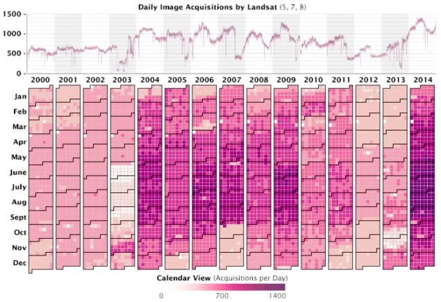
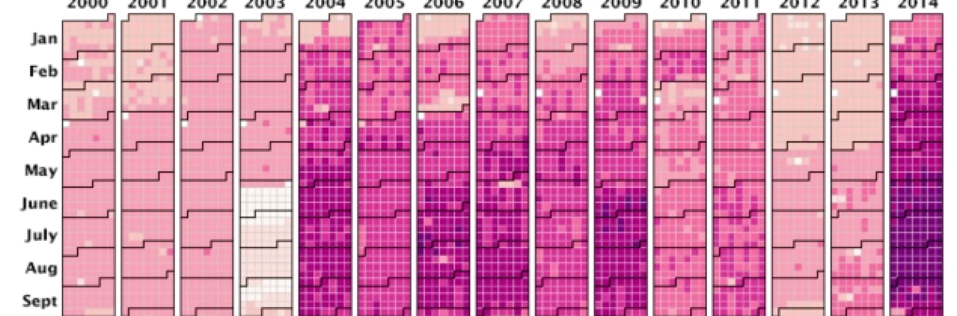
Since January 1, 2000, more than 4.3 million scenes have been captured by Landsat satellites and made available to the public. Landsat 8 was launched in February 2013, significantly boosting the rate to as many as 1,400 images each day. (Graph by Joshua Stevens, using data collected from the U.S. Geological Survey acquisitions archives.)

http://earthobservatory.nasa.gov/Features/LandsatBigData/


Home

Legal Menu

  • Copyright
  • Nondiscrimination Statements
  • Accessibility
  • Site Information
  • Privacy
  • Feedback

© 2025 Regents of the University of California