Wildland Invasive Weeds – Regional Strategic Planning with New Mapping Tool
For the past 12 years, county-based Weed Management Areas (WMA) have organized and collaborated to detect, map and treat invasive weeds around the state. These partnerships, usually spearheaded by County Agriculture Departments, University of Cooperative Extension or Resource Conservation Districts, include a wide array of landowners and land managers --- from U.S. Forest Service, PG&E, local Irrigation and Water Districts, Caltrans, County Departments of Transportation to the California Native Plant Society, local land conservancies and California State Parks. By working together WMA have utilized staffing and funding resources to get the “best bang for our buck” to stop new introductions and the spread of invasive weeds.
Funding for these important partnerships, and the coordinated on-the-ground work, has slowed to a trickle with the state budget cuts. So what NOW? A tighter regional strategy seems in order, to squeeze more from our buck --- and from our agency on-the-ground staffing commitments!
How do we work strategically as a region? By utilizing all the tools in the toolbox including the CalWeedMapper program recently developed by California Invasive Plant Council. CalWeedMapper utilizes historical data and knowledge from local plant experts to document which invasives are where across the state. The data is shown at a coarse level, with notations by quad, based on species distribution and if the infestations are currently being managed. By looking at the weed “pressures” from surrounding geographic areas, weed managers can better understand which weeds to watch for in a detection survey program and which weeds may still be eradicable in a given area.
A four-county regional group has come together to plot our strategy, with Tuolumne, Calaveras, Amador and El Dorado Counties participating. We’ve run CalWeedMapper reports to analyze which plants might be part of a surveillance, eradication or containment plan.
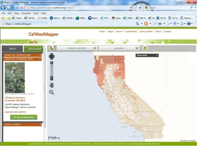
Here’s an example of Canada thistle (Cirsium arvense) shown at the state level via CalWeedMapper:
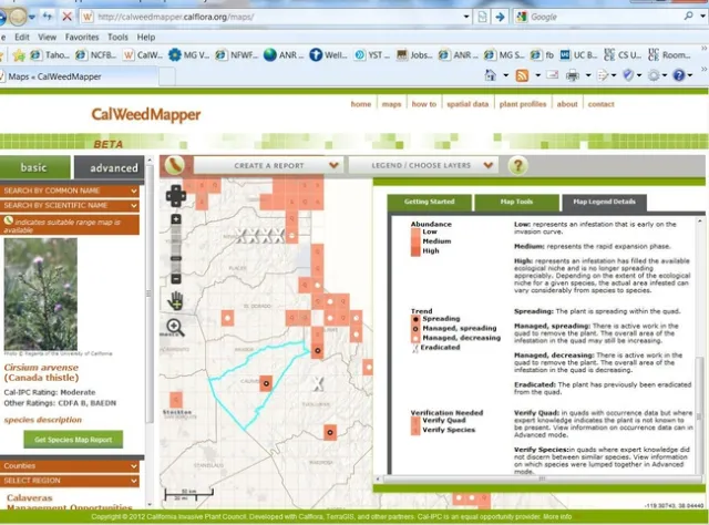
And what we know specifically about the distribution of this plant in the four-county region:
I’m a visual learner --- we CAN stop Canada thistle from sneaking in from the North and East and eradicate it in this region!!!!
CalWeedMapper is available at: http://calweedmapper.calflora.org